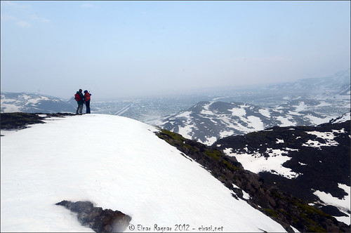
Við gíginn á Stóra_Meitli / On the edge of the crater on top of Stóri-Meitill
| Það var farið á Meitla tvo í dag. Stóra- og Litla-Meitil. Gædaferð með Ferðafélaginu, eitt fjall í mánuði. Skemmtileg ferð í vörmu veðri en helvítis roki. | I was doing my monthly guiding work today. The project was to climb two small mountains close to Reykjavik, Stóri-Meitill and Litli-Meitill. The weather forecast was very warm or even hot according to the time of the year. But it became rather windy so the weather was not so extremely good. But at least it was not raining during the hike as it was in the evening in Reykjavik The number of people participating was between 120 and 130 so it was quite a group and we were 6 guiding the group – all guides where members of my rescue team, HSSR. |
Jarðfræði svæðisins / The geology of the area
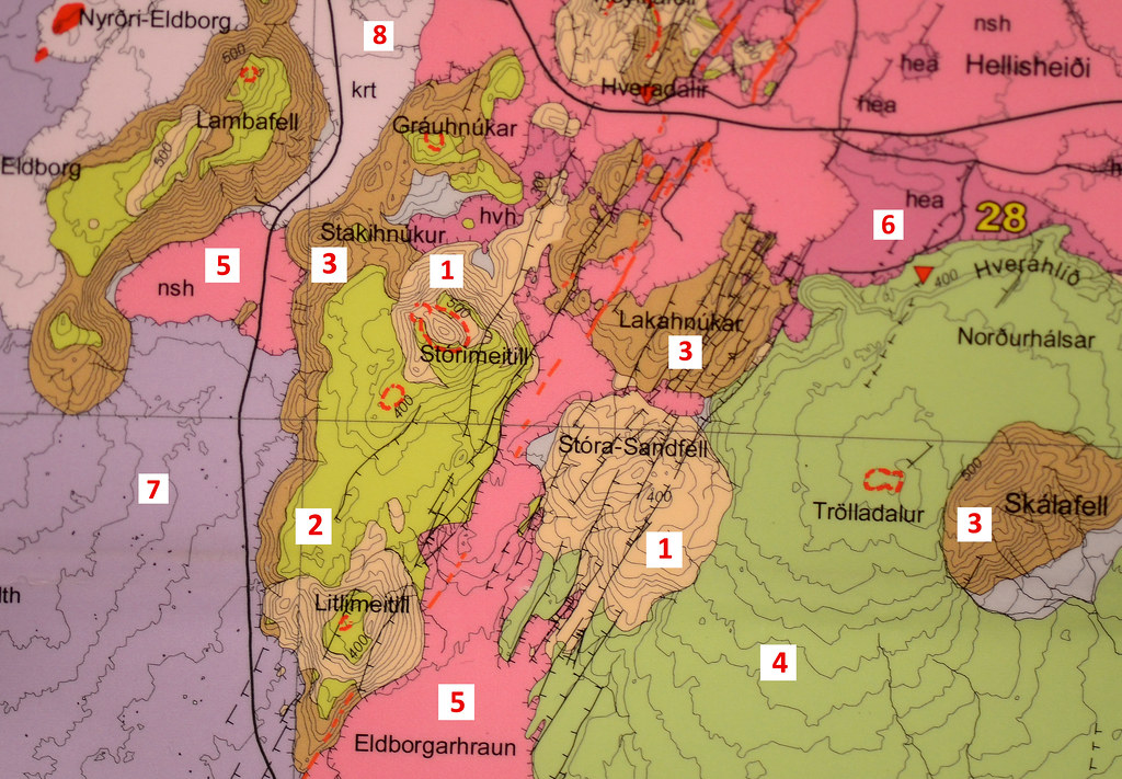
Jarðfræðikort af svæðinu / Geology map of the area
(Kristjan Sæmundsson, Haukur Jóhennesson, Árni Hjartarson, Sigurður Garðar Kristinsson and Magnús Á. Sigurgeirsson, 2010. Jarðfræðikort af Suðvesturlandi, 1:100 0000. Íslenskar Orkurannsóknir)
| Stóri- og Litli-Meitill 24. mars 2012: Jarðfræðikort svæðisins. 1: Móberg frá lokum síðasta jökulskeiðs 2: Grágrýti ofan á móbergi 3: Eldra móberg frá fyrri hluta síðasta jökulskeiðs 4: Aðrir grágrýtisflákar 5: Hraun á bilinu 1900 til 2400 ára og þetta hraun er álitið vera 1900 ára gamalt og gengur undir ýmsum nöfnum 6: Nútímahraun, eldri en 2400 ára 7: Dyngjuhraun, eldra en 7000 ára 8: Dyngjuhraun, yngra en 7000 ára Samkvæmt þessu korti sem er nokkuð áreiðanlegt, þá eru Meitlarnir báðir frá seinni hluta síðasta jökulskeiðs og líklega frá lokum þess þegar jökullinn var farinn að þynnast verulega sem sést af því að grágrýtishraunin hafa náð að flæða þar yfir eldra móberg. Það móberg er frá sama ísaldarskeiði (þ.e. á bilinu 50-100 þúsund ára gamalt). | The geology of the area. The photo above is from a very good geology map published by ISOR couple of years ago. The numbers means: 1: Subglacial hyaloclastite from late Weichsel 2: Compound lava on hyaloclastite 3: Subglacial hyaloclastite from early Weichsel 4: Compound lava 5: Lavas, 1900 to 2400 years old. This particular lava is close to 1900 years old. 6: Holocene lavas, older than 2400 years 7: Lava shield, older than 7000 years 8: Lava shield (Holocene), older than 7000 years According to the map, both mountains (Stóri-Meitill and Litli-Meitill) are from late Weichsel and as far as I understand there was lava coming from the crater in Stóri-Meitill. I’m perhaps making some suggestions but I think the lava was flowing over older hyaloclastite ridge that had formed early in Weichsel. My wild guess is that the glacier was retreating at the same time. In the beginning of the eruption the glacier must have covered the area since the eruption end product became subglacial hyaloclastite. But since the lava flowing from the crater did not flow all the way down from the mountain but leave older hyaloclastite areas on lover places in the mountain I think most likely the glacier was still there in the lover part. |
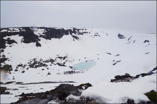
The crater on top of Stóri_meitill. It is somewere written the size of it is approximately 300m x 500m - so ti must have been quite an eruption!
No comments:
Post a Comment